 IMAS Metadata Catalogue
fixed benthic node
Type of resources
Topics
Keywords
Contact for the resource
Provided by
Years
-
Temperature loggers have been deployed at a range of sites statewide in waters ranging between 6 and 22m depth. From 2012, 27 sites around Tasmania are being monitored. This record shows data collected from 2004 up to December 2020. Data is still being collected (April 2023) and will be added to this collection as it becomes available.
-
This dataset consists of data collected by the real-time dissolved oxygen (DO) monitoring system in Macquarie Harbour, Tasmania, originally established under the Sense-T program, continued under FRDC project 2016-067 and deployed and maintained by IMAS. The system consists of 3 strings of acoustically telemetered, optical fluorescence DO, temperature and depth sensors (VEMCO, Bedford, Canada) which measure DO in % saturation, temperature in °C and depth in meters. The dataset spanning the time period from the 1st of January 2017 to the 19th of April 2017 consists of data collected using the first generation of sensors as described above. Subsequent quarterly updates from the 3rd of June 2017 onwards consist of data collected using the new generation of tags which contain a tilt instead of a depth sensor.
-
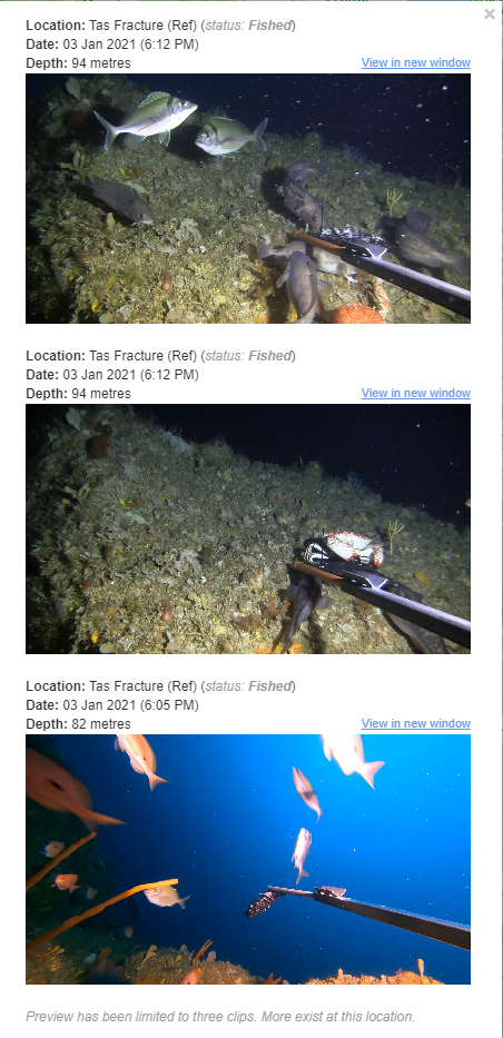
The imagery provides representative and highlight clips from the quantitative sampling of the abundance, body size and diversity of demersal fishes baited remote underwater stereo video (stereo BRUV) in and around Tasman Fracture, Beagle, Huon and Freycinet Australian Marine Parks (AMPs). The dataset allows examination of changes in fish communities over time as part of ongoing monitoring of these AMPs. There are plans for ongoing surveys as part of Parks Australia's management of the AMPs. The methods and key findings of the work are described in detail in Monk et al. (2016) and Perkins et al. (2022).
-
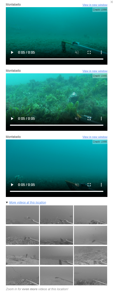
This data is a national compilation of video clips derived from underwater video sampling techniques (e.g. BRUV, Stereo-BOSS) for quantitative sampling of abundance, body size, and diversity of demersal fishes. Current contributors to this data compilation are IMAS and UWA, with the intention that this collection will grow to encompass collections from other research organisations around Australia. As of July 2023, this dataset includes video in and around Tasman Fracture, Beagle, Huon, Freycinet, South-west Corner, Abrolhos, Geographe Bay, Montebello and Ningaloo Australian Marine Parks (AMPs). The dataset allows examination of changes in fish communities over time as part of ongoing monitoring of these AMPs. This record represents a 'parent' record of multiple collections. See individual 'child' records for more information on specific regional collections.
-
This dataset provides predictions of pelagic vertebrate species richness and relative abundance throughout sub-areas of the Oceanic Shoals Australian Marine Park (AMP). Predictive models were constructed from in situ observations made using mid-water stereo-BRUVS (baited remote underwater video systems) deployed at 116 sites within three sampling areas in the western half of the AMP. Sampling took place in September and October 2012 aboard the RV Solander (survey GA0339/SOL5650), as part of an expedition supported by the National Environmental Research Programme's Marine Biodiversity Hub (Theme 3). Expedition partners included the Australian Institute of Marine Science (AIMS), Geoscience Australia (GA), The Centre for Marine Futures at the University of Western Australia (UWA), and the Northern Territory Museum. Full methodological details can be found in the following peer-reviewed publication: Bouchet, P.J., Letessier, T.B., Caley, M.J., Nichol, S.L., Hemmi, J.M., Meeuwig, J. (2020). Submerged carbonate banks aggregate pelagic megafauna in offshore tropical Australia. Front. Mar. Sci. doi: 10.3389/fmars.2020.00530
-
Fixed position oxygen and water temperature logger data from the Macquarie Harbour World Heritage Area (WHA). Two Hobo oxygen data loggers are positioned at approximately 15 m depth at different sites within the WHA, with the intent of monitoring representative mid-bottom water oxygen values in the WHA as these were identified in previous studies to be naturally low due to limited seawater exchange at the harbour entrance, and thus likely to be most susceptible to anthropogenic factors that may increase oxygen demand and alter WHA conservation values. These values include core habitat of the Maugean Skate, a listed threatened species. This work is funded by WHA advisory board via the Nature Conservation Branch of DPIPWE and is part of a larger study being conducted by IMAS undertaking a biological baseline study of the biodiversity of the Macquarie Harbour WHA. This data spans 08/11/14 to present (most recent update 02/02/17).